AwesomeEFIS operation
The rotary encoder is used to control all functionality of the EFIS and extra displays. The encoder functions change based on what screen is active.
Changing screens
The EFIS starts on the AHRS screen by default. Each display, the EFIS and every Extra Display, can be set to start on a different screen. Connect to the EFIS with the EFISConfig webapp, find the display in the Devices card, choose a screen from its Default startup screen list, then click Save.
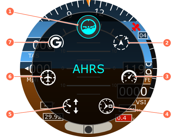
Double-click the encoder quickly to display a menu of the available screens. Screens disabled in the configuration do not appear in the menu and can't be reached any other way. Rotate the encoder to highlight the icon of the desired screen, then single click to select it. The menu closes automatically after 10 seconds, and a long press also closes it without changing screens.
Available screens, numbered clockwise from the top of the menu:
- AHRS / PFD
- ADS-B / Map
- Airspeed
- Altimeter
- VSI
- Directional Gyro
- G-Meter
To disable screens, see Configuration.
Encoder controls
A long press is about 2 seconds. Keep pressing until the function you want happens.
| Screen | Rotate | Click | Long press |
|---|---|---|---|
| AHRS | Adjust altimeter setting | Activate altimeter setting | --- |
| ADS-B / Map | Zoom | Show or hide NEXRAD | Open airport search |
| Airspeed | --- | --- | --- |
| Altimeter | Adjust altimeter setting | Activate altimeter setting | --- |
| Vertical Speed | --- | --- | --- |
| Directional Gyro | Set heading bug | Show or hide heading bug | Start magnetometer calibration |
| G-Meter | --- | --- | Reset min and max G |
Altimeter setting
Rotating the encoder adjusts the altimeter setting in the Kollsman window, and the altitude updates in real time. The setting turns yellow when it has been changed but not yet activated. Click the encoder to activate it, and the text returns to white.
ADS-B / map
Rotating the encoder adjusts the zoom of the display. The distance ring radius is shown in the units selected during configuration, and the units are also displayed in the lower left corner of the display.
As you zoom in below 10 miles, airports are drawn as their runways to scale. Runways drawn in white have known GPS coordinates for both ends of the runway. Runways drawn in yellow do not have GPS positions for both ends of the runway, in this situation the runway is drawn centered over the airports position.
If an AwesomeADSB receiver is connected on the RADbus, aircraft equipped with ADS-B Out are displayed, and NEXRAD is shown as an overlay. Aircraft are drawn at their last broadcast position and track. Altitude difference is shown in hundreds of feet or tens of meters, depending on your configuration.
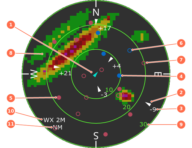
- Ownship: your aircraft, at the center of the map.
- Traffic: an aircraft broadcasting ADS-B Out, drawn at its last reported position and pointing along its track.
- Relative altitude: how far the traffic is above (+) or below (-) you, in hundreds of feet or tens of meters. In this example, -9 is 900 ft below.
- Towered airport, public use: filled blue circle.
- Non-towered airport, public use: filled red circle.
- Towered airport, private or military: hollow blue circle.
- Non-towered airport, private or military: hollow red circle.
- NEXRAD weather overlay.
- Range ring distance: the radius of each ring.
- NEXRAD status and age: see the table below.
- Distance units.
The NEXRAD weather status and report age (in minutes) are displayed in the lower left corner of the display, just above the distance units.
| Display | Meaning |
|---|---|
| WX -- (Grey) | NEXRAD weather not available |
| WX 4M (White) | NEXRAD data available, age under 8 minutes |
| WX 8M (Amber) | NEXRAD data available, age 8 minutes or more |
| WX OFF | NEXRAD data available, overlay is hidden. Single click to display |
A single click toggles the NEXRAD overlay on and off. Data older than 10 minutes is treated as unavailable.
Navigation and ADS-B
Traffic, airports and NEXRAD are not displayed until the EFIS has a valid 3D fix.
Direct-to navigation
The EFIS comes pre-loaded with navigation data for the United States.
- On the map screen, press and hold the encoder until the keyboard screen appears.
- Rotate the encoder to choose a character. Enter the 3 or 4 character airport identifier without the leading K. Select < to backspace.
- Click to confirm the character and advance. Results filter as you enter characters, and only characters that match a valid airfield can be selected.
- Confirm the airfield by selecting Direct To.
The EFIS returns to the map and shows a track to the destination airfield along with the distance remaining. To cancel navigation, long press to bring up the keyboard and select Cancel Nav. Alternatively, enter a different airport identifier to divert to that airfield.
Directional gyro
Rotating the encoder sets a heading bug, shown as double cyan triangles. A single click will toggle the visibility of the heading bug.
When using onboard navigation, a course indicator is shown as a purple triangle.
AHRS
The AHRS is disabled until a stable GNSS 3D fix is acquired. Until then, the horizon does not update with aircraft attitude.
| GNSS satellite indicator | Meaning |
|---|---|
| Red | No 3D fix |
| White | 3D fix acquired, AHRS active |
With the aircraft outside and a clear view of the sky, expect a 3D fix in under a minute. The number of tracked satellites appears near the upper right corner of the display. A properly placed antenna tracks at least 20 satellites.